Hike from the parking lot of Seru Pretu snack to the most Western part of the former plantation of Santa Catharina. At first the hike goes westward till the border with the plantation of Ronde Klip. Then the hike continues to the Northern shore. After a walk along the shore the hike returns to the starting point via a dirt road along the former plantation house of Santa Catharina.
Highlights of this trip:
- the walk along the Northers shore
- the entrance of the Tunnel of Doom
- Boka Labadera
- Plantation house Santa Catharina
This is a rather long hike over mostly flat terrain. Along the coast the underground is rather sharp because of eroded limestone. So best bring shoes with a good sturdy sole.
Parking
The car can be parked in the parking lot of the Santu Pretu snack. Be careful not to block access to the snack or the car wash.
Description of the trail
For a map of the trail check the download link below under the heading "Trail map". Also the track is available for download there.

From the parking lot you need to enter a small path along a fence; to find this path look carefully at the detail map (photo) below under the Trail Map heading. The building at the left hand side is the Toko with the parking lot where the hike starts. Follow the line to find the path along the fence. Follow this small path till you reach the first houses of Santa Catharina. There you follow the dirt road straight on.
When you pass the last house of Santa Catharina along this road start looking for a dirt road to the left. Take that dirt road. From there you follow the dirt roads either with the help of the downloaded map or helped by the track in the Wikiloc or Locus Map app.
The first part of this hike is not very interesting. The area is flat and the vegetation is sparse. At a certain point the dirt roads goes further to the North. At your left you see the Rond Klip mountain. When the road bends to the right the track becomes more interesting. You will pass an old stone wall. The path becomes smaller there and the vegetation becomes more interesting and denser. Also there the path is marked with blue ribbons.
Continue the hike till you reach the coast (no blue ribbons here anymore) and then continue on in Eastward direction along the coast.
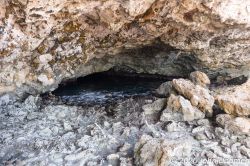
Before you reach Boka Labadera, a large bay, you will see another strange-looking kind of bay but without an apparent connection with the sea. This is where the Tunnel of Doom can be found. This "bay" has a connection with the sea but the connection is in the form of an underground tunnel to the sea. It is a knows dive spot but only for very advanced divers because you are diving under a ceiling, so in case of emergency there is no direct way up to the surface. Don't dive here withour an experienced guide.
As a hiker you can check the entrance of the tunnel of doom and get an idea how dangerous a dive here can be. Then continue along the coast till the next real bay, Boka Labadera. This is a large bay with a wide entrance from the sea. At the Eastern side of the end of the bay a path starts to the South in the direction of the plantation house. Take that path.
If you like you can visit the plantation house. It is in a bad state so be careful when you enter the building.
Along the road at the right hand side are the remains of a small building next to a water tank. It looks as if here a pump was located to distribute the water. There are more water tanks on both sides of the road.
Follow the road till you reach once again the small path along the fence. Take that to return to your car.
Track of this hike on Wikiloc
Link to the track of this hike on Wikiloc (opens in a new window).
The track can be downloaded but a better option is to install the Wikiloc app on your smartphone; when you click on the download link with the app installed on your phone the link opens in Wikiloc (can take some time) and you are able to follow the track.
It appears that this only works for the paid Premium version of this app.
As an alternative the free version of the Locus Map can be used. To use this app you need to download the track in GPX-format either from Wikiloc or directly from this page (see below under "Trail map").
Location
Pictures
 The first part of the trail - open terrain
 Remnants of an old wall
 Wind energy
 The sea is reasonably calm
 Small natural salt lakes on the shore
 This plant survives in harsh conditions
 This crab didn't survive
 Strange bay - the location of the Tunnel of Doom
 Entrance of the Tunnel of Doom
 Boka Labadera
 Water tank along the road
 Remnants of a pump house
 The plantation house of Santa Catharina
Trail map (download)
Map with route; right click and Save As GPS track Visit Website
