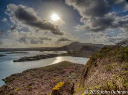
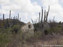
Hike from the Caracasbay to the top of the Kabrietenberg (78 meters high) which is the Dutch word for Mountain of the goats. From there we take a route to the coast of the Spanish Water where we continue along the coast.
This is a rather challenging hike partly over easily accessible paths, partly over rocks. The pace is somewhat higher than during most of my other hikes.
Highlights of this trip:
- View from the top of the Kabrietenberg
- Various views from the path along the coast
- Challenging climbs and descends
- Walk along historical buildings: quarantine building, fort Beekenburg
The hike is completely different from the hike over the Caracasbay peninsula. This is a challenging hike without a lot of explanation and with no extended visit to the historical buildings.
Parking
The car can be parked in front of the last restaurant at the Caracasbay known as Pop's Place.
Description of the trail
For a map of the trail check the download link below under the heading "Trail map". Also the track is available for download there.
From the parking lot in front of the restaurant you have to cross the volleyball field and start walking uphill on the asphalt road. Take the first asphalt road to the left.
Where the road goes to the right in the corner a path can be found that goes downhill; take that path; it leads to a dirt road; go to the right and follow the dirt road (along the boat mooring) till it reaches another asphalt road. Continue on the asphalt road; after passing the backside of the former Baya Beach restaurant take the first asphalt road on the left hand side. Follow this road uphill; when it reaches a dirt road continue on the dirt road straight on. The dirt road goes to the left but you should continue straight on via a small path till you reach a somewhat more open area. Immediately on the left there is a small path where the trail to the top of the mountain starts. Take that path and follow it to the top.
Enjoy the view from the top and take a rest there as long as you like. Then descent via the same path back to the point where the trail to the top started. Go left; only a few meters farther there is another path on the left hand side. This is the trail around the mountain. Start this trail and continue till you reach a large overhanging rock formation. There you can take another rest if you want. After continuing take the first path on your right hand side next to a nice Brasia tree. Follow this path and choose for the path to the right where there is a choice. This path leads to the coast. From there on you start a trail more or less along the coast; look for yellow marks on the rocks and trees to stay on the right path. If you think that you are no longer on the path you probably aren't; trace back or check around and look for yellow marks. And while hiking don't forget to enjoy the view over the water.
This part of the trail asks for some rock climbing and leads sometimes close to the edge. So be careful.
When you reach the open sandy area opposite the Santa Barbara resort take the dirt road away from the coast. Cross the asphalt road and continue on another path perpendicular to the asphalt road. When you reach the asphalt road again turn right and continue on the asphalt road till your reach the parking area of Directors Bay. There you have two option to continue; an easy one and a more challenging but nicer one:
- For the easy one take the path uphill to the asphalt road and continue on that road till you reach the quarantine building. If you like take a look at the building and return then to the asphalt road.
- For the more challenging one take the small path in the far right corner of the parking lot; there you go down to the water level. Continue along the coast; look for yellow marks on the rocks to guide you in the right direction. At a certain point the marks show you to go uphill; there starts a steep climb to the Quarantine building. At a certain point you will see a chair made of wooden pallets; take a rest and enjoy the view if you want. Then continue to the Quarantine building. If you like you can visit the Quarantine building and then continue till you reach the asphalt road.
From here on the trail continues along the former Baya Beach restaurant to Fort Beekenburg. Enter the fort via the stairs. The trail continues via the fort to a point exactly opposite of the entrance next to the former toilet (2 seats). There starts a path over the rocks; also here you have to follow the yellow marks that lead you to the parking area next to the pier in the Caracasbay.
Continue on the asphalt road till you reach the car. This completes this rather challenging hike.
Track of this hike on Wikiloc
Link to the track of this hike on Wikiloc (opens in a new window).
The track can be downloaded but a better option is to install the Wikiloc app on your smartphone; when you click on the download link with the app installed on your phone the link opens in Wikiloc (can take some time) and you are able to follow the track.
It appears that this only works for the paid Premium version of this app.
As an alternative the free version of the Locus Map can be used. To use this app you need to download the track in GPX-format either from Wikiloc or directly from this page (see below under "Trail map").
Location
Pictures
 The track of this hike
 View on the Quarantaine building from the Kabrietenberg
 View from the top
 View from the path on the Eastern side of the peninsula
 Nice green Wayaca tree
 Nice rock formations
 Small pebble beach
 View on Director's bay
 Quarantaine building
 Fort Beekenburg on top of the rock
 Water building
 Outside wall of Fort Beekenburg
 The ravine of the fort contains water
Trail map (download)
 GPS track Visit Website
